Saturday, April 8, 2017

A Relaxing Day At Sea

Today was the day at sea as we crossed the Ionian Sea from Corfu last night and made our way across the base of the Italian peninsula throughout the day.

The clear blue sea met the fabulous weather.  I was able to spend a good deal of the day relaxing in the sunny, 60 degree day!

That may also have included a brief afternoon nap in the shade of my balcony. :)

In the mid afternoon, we passed through the Strait of Messina.  Below is the coast of Sicily.

Several hours later, we passed several small volcanic islands as well as the island with Mt. Stromboli.  This is the first time that I have seen an active volcano.

Tonight, there was little activity other than the smoke coming from the top in a steady stream.

When we came around the other side of the island, the track of previous flows became clearly visible.

We passed by the island very closely!

Sunset at sea....next stop is Italy!

Friday, April 7, 2017

The City, Corfu

Corfu tradition believes that the island and its people are protected by St. Spyridon.  Born in Cyprus, St. Spyridon had no connection to Corfu until 1453 when Constantinople fell to the Turks.  When that happened, many of the Christian and Orthodox treasures, including the relics of saints were removed to keep them safe.  

At the time, Corfu was held by the Venetians who were welcoming of religious freedom and Corfu had demonstrated that it was safer than mainland Greece.  Many relics, including the body of St. Spyridon were sent to Corfu.  

When the Turks laid siege in 1716, many prayed to St. Spyridon to save them.  When the seas storm greatly damaged the Turkish fleet, the people of Corfu believed that St. Spyridon sent the storm and was their protector, so he became the patron saint of Corfu.

The St. Spyridon Church Bell Tower, the highest structure in the city, is at the center of the photo below.

The city streets are medieval in design and very narrow.  The entire old city is for pedestrians only.

The town hall, below, was once a theater, but it was too small and another was built in it place.  It was built in 1663 and at the front, there are four flags that hang above the entry.  The national flag of Greece, the European Union flag, the UNESCO flag (because the area is designated as a world heritage site and is protected) all hang together.  The fourth flag is the flag of Corfu which contains a gold ship that represents the ship of Odysseus and is a nod to their traditions and beliefs.

The Old Fortress, Corfu

The Old Fortress was originally built by the Byzantines in the 8th century and then it was expanded by the Venetians in the 16th century and the British in the 19th century.

The fortress assisted Corfu in its defense. Despite several sieges by the Ottoman Empire, it was the only island in the region not to be occupied by the Turks.  In 1716, the Turks attempted to conquer with a force of 30,000 soldiers and 46 canons, but 8,000 soldiers on the island held their ground.  A sea storm came through and damaged the Turkish fleet enough that they retreated.

While sieges from the Turks were held off, the island was under the control of many states during its history.  It was controlled by France, Russia, Great Britain, and was finally reunited with Greece in 1864.

Inside there is a combination of military, religious, and social structures within the walls of the fort.  Below, the thick cliffside walls of the fortress contain canons fir defense and surround the open space that was once the forum of the city with the church in the background.
At the end of the forum and overlooking the Ionian Sea, St. George's Church was added to the fort by the British in 1841.

Corfu, Greece

Corfu is the western most point of Greece today.  It is considered the capital of the Seven Ionian Sea Islands.  The former colony of the ancient city-state of Corinth, Corfu was also part of the Roman and Byzantine Empires.  Today, the small island produces 12 tons of olive oil annually and supplements its agricultural economy with spring and summer tourism.  Corfu is also the birthplace of Prince Phillip, husband to Queen Elizabeth II of Great Britain.

Along the western side of the island are the two islets below.  The white buildings in the center make up the Monastery of the Virgin of Vlacherna which is connected to the Kanoni peninsula with a small bridge.  The smaller islet behind it is called Pontikonisi.  It contains the 11th century Byzantine church of St. Panteleymon.  There is a legend on the island that the islet is actually the Phaeacian ship that brought Odysseus (from Homer's story) to Ithaca and was petrified by Poseidon in his anger.

Below is a view of the Old Fortress of Corfu from the western side of the bay.

The walk back to the ship from the old city was a bit windy.  The rain held off with only a few sprinkles, but the wind and the clouds were a bit ominous.  The port was under construction, so walking back to the ship from customs was necessary, but it gave me a view of our ship eclipsed by a Princess Cruises ship that was easily twice the size of ours. That is way too many people and accounted for the crowds we had today that we had not seen in the past.

These are the first white cap waves I have seen this entire trip, but we have a few hours before the ship sails.

When we sail tonight, we will will take all day tomorrow to sail around the "heel" of the Italian peninsula.  Tomorrow is my day to sleep in and relax before reaching Naples!

Thursday, April 6, 2017

Dubrovnik, A Port City

The original port of the city was located at the east entrance.  Today, the modern port is located to the west of the old city.

During the Middle Ages, the port (below) was extremely active and had its share of experience with the plague.  A policy of quarantine was established that required ships to wait in port for 40 days before entering the city.  Later, the buildings to the left were used to house those in quarantine, which continued until the 19th century to prevent such diseases as yellow fever.  Dubrovnik took advantage of inspecting cargo during quarantine, which allowed them to access information as well.

The building below was one of the few that survived the 1667 earthquake.  The details of the building provide insight into the style of those that were destroyed.

It was originally built in 1516 and used as a palace.  When they gained their independence from the Roman Empire, the Dubrovnik Republic used this building as a customs house (as it was conveniently located by the old port), the state mint (where they made their currency), a bank (for currency exchange for foreigners), a treasury (to hold the wealth of the city), and the armory (to store weapons and gun powder).  Today, this Gothic-Renaissance building is used as the National Archives.

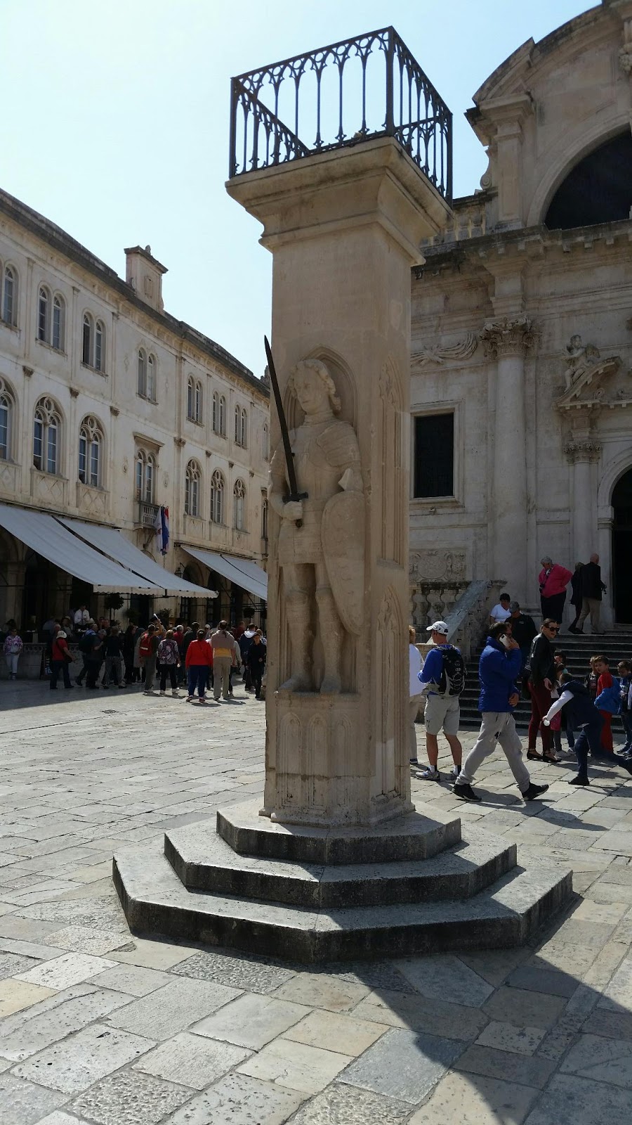
In front of the Church of St. Blaise and in the center of the marketplace is a statue of Sir Orlando known as the Orlando Column.  Built is 1480, the statue was more than decorative.  In the Middle Ages there was no uniform standards of measure.  This made trade complicated because no two regions agreed how to measure goods.

In Dubrovnik, they used Orlando's elbow (approximately 51 cm) as the stand measure for goods sold in the marketplace.  At the foot of the statue, the length was laid out for anyone to use for reference.  If someone tried to cheat a buyer, it would be tested at the column.  If the merchant was found to be cheating his customers, one finger would be cut off for each inaccurate measure.  Customers could determine the reliability of the merchant based on the number of fingers he had!

While Dubrovnik maintained their independence throughout the Middle Ages, they were not able to stop Napoleon who conquered the city in 1808.  He did not destroy the city, but was looking for a place to house his soldiers as they began to move east.  As part of that plan, he built a fort on an island off the coast of the city that had been the home of  a Benedictine Monastery.

According to Ivana, this action cursed the island for anyone that owned it or slept the night on it.  Napoleon lost in the east and the city became part of Austria-Hungary and the island came to be owned by the Hapsburgs.  Those that know their history know that this was a very unlucky family and one member's death is marked as the start of World War I.  Today, no one owns the island and no one sleeps there.  It is a natural park.

Dubrovnik switched hands over the course of the 19th and 20th centuries.  It was held by France, Austria, England, Russia, and Turkey.  During World War II, it was controlled by the fascists and became part of Yugoslavia.

During the Homeland War from 1991-1995, Dubrovnik spent five months under siege by Sebian and Montenegrin forces.  One of their most effective defenses was a fort that Napoleon built above the city further from the sea to keep watch on the people.  At the top of the photo below, the fort was able to defend the city and prevent any occupation by enemy forces.
This photo was taken from outside the western gate entrance.  The fort is at the very top of the mountain, in the center.

The Stradun (Dubrovnik's Main Street)

In 1667, the city suffered a devastating earthquake that leveled a large portion of the city including homes, government buildings, markets, and churches.  Not wanting to appear weak and vulnerable, Dubrovnik never shared the extent of the damage and number of dead.  Instead, they built over the rubble and worked to quickly build a new public area.  

(Below) The street, known as the Stadun, became the widest street in the city with a line of similar buildings that run the length of the city from the western gate to the port at the eastern gate.

All of the buildings on the Stardun have entrances like those in the photo below.  The street was filled with vendors and during the Middle Ages, customers did not walk into a store as they do today.  Notice that next to the door is a window.  That was where the vendor would sell his goods at a counter that was open to the street.

The bell tower was built in 1441 and survived the earthquake.  It stands at the eastern end of the Stardun and the bell, cast in 1509, strikes each hour based on the time.  According to Ivana, the reason that the bell strikes are repeated three minutes later is that most people can't see the time on the clock from where they are in the city and often do not pay attention to correctly count the time as the bells begin chiming the hour, so the repeat is for them.  She says this is not because they are lazy; it is just that they are not a people that are in a big hurry.

Below is the Baroque Church of St. Blaise that was built in 1706-1715 after the Romanesque church was destroyed in the earthquake.  Dubrovnik appealed to the Pope to assist with the rebuild of the church, but hid the devastation from the other states to keep them from getting any ideas of invasion.

The church sits higher than the rest of the street, but not because there was a natural hill.  To prevent the true scope of the destruction to be seen by outsiders, they piled the rubble and built the church on top of it.

The church overlooks the marketplace and was believed to keep the merchants honest by having St. Blaise watching from above the church.

The Cathedral of the Assumption of the Virgin Mary was built in the 13th century.  It does not face the city, but rather the entrance to the port.  The reason was to proclaim to those coming from the east that this was a Christian city.

Dubrovnik's Roman Connection

For a time, Dubrovnik was in the center of the Roman Empire and was safe from concerns of invasion.  This allowed the port city to grow and thrive without the fortifications that would be necessary during the Middle Ages.

Below is a photo of a section of the interior medieval wall near the western gate.  The wall was built using part of the aqueduct that was built by the Romans.  Notice the portion of the wall where the stones are at an angle.  The Adriatic Sea did not provide fresh water, but the aqueduct brought water from 18 km north of the city.

Cisterns, like the one below, connected to the aqueduct and provided fresh water to the people in the city.  This cistern, called Onofrijeva fontana, was built in 1438.

Water conintuously runs from the pipes coming from the mouths of the lions. (Below)

The people living in the city during the Middle Ages feared that the aqueduct could be poisoned or cut off in the event of an invasion. So, they converted the water system to wells from below the city.

Ultimately, this worked out well for people at that time and protected the people again hundreds of years later.  During the Homeland War (1991-1995), the city was under siege and water was cut off from the rest of the world for five months.  The people were able to tap into the older system to provide drinking water and water they could use for toilets.  This prevented disease, which could have been devastating to the city.

Our tour guide, Ivana (below), is an arachaeologist and expert on the city.  She guides tours in the spring and summer because excavations are not permitted during the tourist season.  She lived during the siege of the Homeland War and shared with us that she can live without her smartphone, but never wants to live without flushing toilets again!  I will share more of her stories in the next posts.